Bicycles belong in wild places.
Bicycling and Wilderness
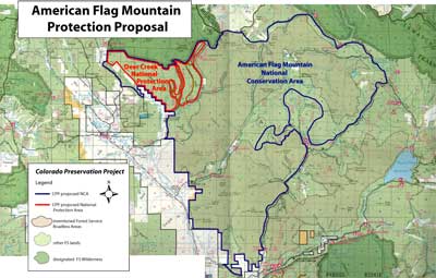
click image for full map (400kb)
American Flag Mountain
Proposals:
American Flag Mountain National Conservation Area
Deer Creek National Protection Area
Agencies: USFS
Counties: Gunnison
Nearest City of Town: Crested Butte
Location: between Crested Butte and Taylor Park, west of Spring Creek.
Description:
Gunnison National Forest lands around American Flag Mountain offer a wealth of trails and roads used by thousands of recreation visitors of all stripes each year. Included within this zone are the Deer Creek, Double Top, Block and Tackle, 409, Deadmans’ Flagg Creek, Bear Creek, and Mysterious Lake trails. Popular 4WD roads include Brush Creek up to Pearl Pass, Cement Creek, and part of the Italian Mountain loop.
Most of the area is open to motorized travel. NCA status would allow this use to continue on existing routes. The one non-motorized route is the extremely popular Deer Creek Trail, which traverses land across the East River from the Mt. Crested Butte ski area. This backcountry area harbors a large elk herd and has provided forage for local ranchers for several generations. Scientists with the Rocky Mountain Biological Laboratory, located at the north end of Deer Creek area, have been studying the ecology of this area for many decades. The CPP would ask Congress to apply a National Protection Area designation to Deer Creek, within the larger NCA.