Bicycles belong in wild places.
Bicycling and Wilderness
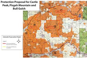
click image for full map (408kb)
Castle Peak, Bull Gulch, and Pisgah Mountain
Proposals:
Castle Peak National Protection Area
Bull Gulch National Protection Area
Pisgah Mountain National Protection Area
Agencies: BLM
Agency Status: WSA
Counties: Eagle
Nearest City of Town: Dotsero
Location: Along the Colorado River, 5 miles north of Gypsum, Eagle County
Description:
Castle Peak’s deep woodland and sage-grass meadows create important wildlife habitat. The abundance of elk, deer, grouse, and raptors in turn make the area popular with hunters. With easy access from I-70, Castle Peak offers valuable recreational opportunities to Front Range residents.
North of Eagle, Bull Gulch cuts through the same deep red sandstone of which the Maroon Bells are formed. From its 9700 foot forested rim, the sculpted canyon drops dramatically, angling northwest to empty into the Colorado River.
8600 foot Pisgah Mountain lies at the center of a rugged area, bounded on the north by the striking canyon of the Colorado River. The river’s riparian ecosystem along with the montane life zone on the slopes of Pisgah lend this roadless unit visual and biological diversity. The area receives relatively little use though it offers varied recreational opportunities, especially to those craving more isolated backcountry experience. CPP recommends that each of these three roadless parcels be designated a National Protection Area.)