Bicycles belong in wild places.
Bicycling and Wilderness
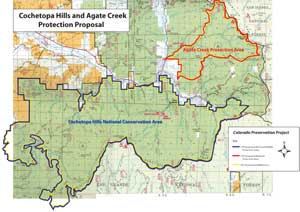
click image for full map (342 kb)
Agate Creek
Proposals:
Agate Creek National Protection Area
Agencies: USFS
Agency Status: inventoried roadless area
Counties: Gunnison and Saguache
Nearest City of Town: Sargents
Location: along the west side of the Continental Divide between Monarch Pass and Marshall Pass
Description:
This small Protection Area drops from the Continental Divide just south of Monarch Pass. From U.S. Highway 50, which forms its northern boundary, drivers crossing the Pass can see Agate Creek’s deep canyon. Bicyclists enjoy riding from Monarch Pass south along the Crest Trail, then dropping down through Agate Creek to Sargents. CPP proposes Protection Area rather than Wilderness status, to allow continued access by cyclists.